


GIS Portfolio
Prototypes and Experiments
Buffalo Village (46Pu31)
Prototype animation of a reconstructed Fort Ancient village along Kanawha River in West Virginia. This was created using Google Earth and Google Sketchup.
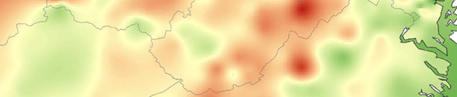
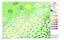
Frost Free Days 1602-1700
The data is set to show Medium level frost free days (# of days between 32 Degrees Farenheit) at the 50th percentile. Red is less than 1 growing cycle, Yellow 1-1.9 growing cycles, and Green is 2+ growing cycles for Northern Flint Corn. 80 days is the estimated minimum growing cycle for this variety of Corn.
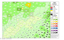
2010 Census: Zipcode Areas, WV Native American Populations
This set of maps was developed to examine the localized populations of people identifying as Native American to determine the best location for a meeting about current Native American political issues in the state of West Virginia.
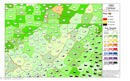
2010 WV Archaeological Site Data By County

This set of maps was developed to show the types and distribution of archaeological sites in WV. Future work will use point data and cluster analysis once the state makes the data available ot researchers. This is the beginning of a predictive modeling project that is in the beginning stages.
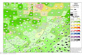
WN NAGIS: Census 1790-1900 - Race by County: Beta Sept. 2015
This set of maps was developed from the University of Vigrinia Library Historical Census Browser. This is just the first run from which I am seeking editorial comments from collegues for additional data, formatting and explainations. Future work will include the 1910-2010 census data formatted in the same way. 1790, 1800, 1810, 1820, 1830, 1840, 1850, 1860, 1870, 1880, 1890, 1900 are below.

1790 - 1800

1810 - 1820

1830 - 1840
1850 - 1860

1870 - 1880

1890 - 1900